Skip to content

Marine Monitoring

Overview

Keeping Watch Over Our Reefs

Monitoring the health of our reefs is at the heart of what we do. Every day, staff and volunteers survey the reefs along 70 km of southern Negros Oriental's coastline, from Dumaguete to Santa Catalina.

We dive both inside Marine Protected Areas (MPAs) and at unprotected sites. Our trained volunteers identify and count key indicator species, and note their condition, which tells us how much pressure a reef is under and how resilient it is. Because MPAs are there to secure food for local communities, the fish and invertebrates people catch and eat are our main measure of whether a protected area is working. The corals and other substrates that hold the whole reef together come a close second.

Each site is surveyed in three depth ranges. Survey lines run parallel to the shore, so every line stays within its depth range, and they are placed at random within that range.
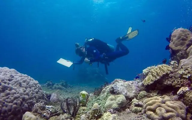
Two volunteer divers recording reef survey data on underwater slates

Citizen science

Real Science, Collected by Volunteers

Citizen science is scientific research that members of the public help carry out. At MCP, that means volunteers from all over the world learning to collect reef data the same careful way, every time.

This is where citizen science shows its real power. With trained volunteers in the water every day, we can survey every site at three depths, repeat each survey several times, and do it all again every three months, year after year. Collecting data at that frequency and scale goes far beyond what most academic research budgets or timelines allow, and it has built deep, long-running datasets that are a treasure trove for researchers.

Volunteer data is only useful if it can be trusted, so we put a lot of work into keeping it consistent.

  • One specialty at a timeEvery volunteer learns one survey type in depth: substrate, fish or invertebrates. People who stay 16 weeks or longer, or who come back, often learn a second or even a third monitoring protocol.
  • Tested before it countsIdentification tests have rigorous pass marks. Everyone must also complete a mock survey alongside a staff member, recording results at least 90% the same as theirs, before joining a survey team.
  • Checked the same dayData goes into our database the same afternoon and is checked against the dive slate it came from.
  • The same method, year after yearFixed depth ranges, line lengths and survey times mean results from different teams, seasons and years can be compared.

Methodology

From Reef to Report

We use stratified random sampling: each reef is divided into three depth ranges, and survey lines are placed at random within each one. Every site and depth is surveyed a calculated number of times to improve accuracy, and the full set is repeated every season (every three months). That adds up to a minimum of 2,016 surveys a year.

  1. Get the assignment

    Each buddy pair is given a site, a depth range and a survey type, followed by a site briefing before they get in the water.

  2. Lay the line

    The pair reels out a 30 m transect line over continuous reef, using a dive computer to stay within the depth range and a compass to stay parallel to the shore.

  3. Record the data

    Working side by side, the buddies record what they find on underwater slates. What they record depends on the survey type, as explained below.

  4. Enter and check

    Back at base, volunteers enter their data into our online database the same afternoon, then compare it with their slates. Any mistakes go straight to a staff member to be corrected.

  5. Analyse and share

    We analyse the data every season and share it with the Local Government Units to support their coastal resource management. The Bureau of Fisheries and Aquatic Resources (BFAR), the Department of Environment and Natural Resources (DENR), other NGOs and visiting researchers use it too. You can explore the data yourself, and if you're a researcher who would like access to our raw data, please get in touch.

Volunteer diver recording data beside a transect line on the reef Survey diver with charts of MCP reef data

What we record

Three Survey Types

To keep training manageable and the data consistent, our monitoring is split into three specialties. The diagrams are drawn to scale.

Substrate survey: a point recorded every 25 cm along a 30 m line, with a predation survey 2.5 m either sidePredation survey, 2.5 m each side120 points, one every 25 cm30 m

Substrate

What the reef is made of: coral growth forms, algae and other substrate types, plus signs of stress. Every 25 cm along the line, the diver records what lies directly beneath it.

Their buddy usually runs a predation survey at the same time, looking for coral-eating animals within 2.5 m of either side of the line.
Fish survey: a 5 m wide belt along a 30 m line, one diver counting each side5 m wide belt, one diver on each sideWait 15 min, then count for 10 min30 m

Fish

After laying the line, the pair waits 15 minutes for the fish to settle back into their normal behaviour. Then, within 10 minutes, each diver counts and sizes the fish from our indicator list on their side of the line.

Fish that cross from one side to the other are only counted once.

Invertebrate survey: each diver searches one 2.5 m side of a 30 m line in an S-shaped patternS-shaped search of each 2.5 m sideUp to 30 minutes per survey30 m

Invertebrates

Many invertebrates hide in cracks and crevices, so this is a slow, thorough search. Each diver swims an S-shaped pattern from the line to the outer edge of their side and back, counting and sizing the invertebrates on our indicator list.

Judging the 2.5 m width matters: search 3 m by mistake, and the reef looks richer than it is.

The dataset

Three Million Observations and Counting

Because we survey the same sites, at the same depths and with the same methods every three months, the numbers add up. Since September 2017, our survey teams have recorded around three million observations, one 30 m line at a time.

  • 15,000+surveys at 15+ sites in Southern Negros
  • 2 million+fish identified and counted
  • 550,000+substrate points recorded, one every 25 cm
  • 160,000+invertebrates found and counted
  • 100,000+coral predators recorded, mostly coral-eating snails
  • 13,000+pieces of trash logged on the reef, now a study of its own
  • 375 kmof transect tape laid along the reef
  • 900+ daysunderwater on survey dives, over 21,000 hours in total

A record this long and this regular lets us tell a real trend from a bad season, compare protected reefs with unprotected ones, and give local governments numbers they can plan with. Explore the data.

Source: our monitoring database, September 2017 to August 2026, including a two-year pause during the COVID-19 pandemic.

Volunteer involvement

Becoming Survey Ready

Before joining the surveys, every volunteer completes a thorough training program in species identification and survey methodology, in small groups with an experienced staff member or intern. It's an outstanding way to learn marine biology and scientific diving, and once you're survey ready, every dive has a mission.

Optional

Dive training

Most volunteers start their stay by building or upgrading their diving skills through our PADI courses.

  1. Introduction week

    Refresh dives for buoyancy and trim, plus introductions to substrate, fish and reef monitoring.

  2. ID training

    Presentations, ID dives and quizzes for your survey type, ending with a dry test and an underwater test.

  3. Transect practice

    Practice surveys on real lines, with your teacher surveying alongside you to check your results.

  4. Survey ready

    Pass a mock survey with a staff member, then join the survey teams along the coast.

After the introduction week, specialty training usually takes two to three weeks, depending on the survey type and your own pace. Good buoyancy matters as much as good identification: a piece of coral broken off by a careless fin can take 2 to 10 years to regrow. If you need extra practice, we'll give you the time. Read more about why we dive the way we do.

Where we survey

Our Survey Sites

Our survey teams monitor 15 sites along the coast of southern Negros, in Zamboanguita, Siaton and Santa Catalina. Twelve are inside marine protected areas and three are control sites outside them, so we can compare protected and unprotected reefs. Faded flags mark sites we have surveyed in the past.

Santa CatalinaSiatonZamboanguitaDauinBacongValenciaDumagueteApo IslandBohol SeaMt Talinis 1,903 m5 kmN

Zamboanguita

Siaton

Santa Catalina

Dauin

Map data: © OpenStreetMap contributors (coast and roads), geoBoundaries/NAMRIA (municipal boundaries), © ESA WorldCover 2021 (towns). Elevation and depth: Mapzen Terrain Tiles.

Before you arrive

Get a Head Start

Our monitoring primer is a visual introduction to the underwater work our volunteers do. It's a good place to start, whether you're already booked or still deciding.

Want to start learning your species? Try our online quizzes for fish, invertebrates and substrate, or find flashcard decks on our volunteer downloads page. You're welcome to email us and ask which survey type you'll be working on.

Diver recording a reef survey in sunlit shallow water

Your next step

Want to volunteer with us?

Apply now